|
#1
 12-20-2004, 07:56 PM
|
||||
|
||||
|
The initial post that was found regarding this sad accident appears in the following. IMPORTANT - more specific information regarding the accident circumstances and weather following in posts below this one.
The following is reposted from http://www.skypilotkiteboarding.com/...opic.php?t=500 "Yesterday (Dec. 19, 2004), Lawrence from Alberta Beach was killed while kiting alone on the lake when hit by a huge wind storm. Lawrence would be known by anyone who has spent time in Ventana. He was a lifelong windsports enthusiast and acomplished and experience kiter. A strong wind storm swept across the lake around noon yesterday. Winds prior to the storm were gusty 30km/hr the sky was clear and temps were warm and rising. The storm gave almost no warning, from the time clouds became visible on the horizon to the time it hit was 15mins or less. Lawrence was riding a depowerable 10m foil with a very good quick release system. When the storm hit winds increased from 30km/hr to over 110km/hr in 20 seconds or less. In the area cars were flipped over, roofs ripped from buildings and trees toppled. Witnesses saw Lawrence being dragged across the lake at a tremendous rate of speed, on his back with his board in front of him before he was picked up into the air and hurled into the side of a church. I believe the church is about a block into the townsite of Alberta Beach. Lawrence would have had to have cleared a huge stand of trees and a row of houses and businesses. He was pronounced dead at the scene. This incident has dealt a tremendous blow to the small Edmonton Kiting community. World wide there have been kiteboard related deaths, but this event has hit very close to home. Alberta kiters, B.C. kiters we are at risk too. I hope the Canadian Kite community can use this event to start a discussion on saftey. Think carefully about the routines you follow when you kite, are they as safe as they can be? I know the areas in my kiting activities where I take chances, I know were I can do better, can you identify yours. Think about the people in your crew who take chances when they kite, talk to them now. Please be careful." and "New info: From some new information gathered it looks like Lawrence had seen the upcoming storm and had retuned to shore to avoid it. It sounds like he was near the shore with his kite depowered on the leash waiting to for the storm to pass when the wind hit. There was enough force in the depowered kite to pull him onto his back and quickly towards the shore for aprox. 100ft before lifting him up 3 or four feet and striking him into the building. The church was on the shore line amongst the first row of buildings in town. He was not lofted over the row of buildings. Lawrence had a quick release on his leash line that would have enabled him to ditch the kite had he had time. The leash was attached to his spreader bar. The change in the weather was so drastic that he did not have time to react. I will post more information as it becomes available. Global telivision has a news crew in the area today gthering more info for tonights 6pm news"
__________________
FKA, Inc. transcribed by: Rick Iossi 
|
|
#2
12-20-2004, 08:11 PM
|
||||
|
||||
|
Reposted from:
http://www.canada.com/edmonton/edmon...b-c3604c446123 "Kiteboarder dies in windstorm mishap Gale slams man into abandoned church Archie McLean The Edmonton Journal Monday, December 20, 2004 CREDIT: Ed Kaiser, The Journal This tree, which fell during Sunday's fierce windstorm, stopped traffic on 84th Avenue near 107th Street. Click here to find out more! EDMONTON - A 46-year-old man was killed Sunday afternoon when winds topping 100 kilometres an hour picked up his snow kiteboard and slammed him into an abandoned church in Alberta Beach. The accident happened just after noon on Lac St. Anne, a popular spot for kiteboarding enthusiasts year-round. Louie St. Laurent didn't see the accident, but he saw the wind that precipitated it. "I was actually out on the boat launch, overlooking a dark sky," he said. "All of a sudden, I looked out on the lake, and could see kind of a rolling wall. It looked like water, but it was actually the wind." At first, St. Laurent saw the kiteboarder moving slowly across the frozen lake, about 60 kilometres west of Edmonton. "I thought, geez, I wonder if he'll be all right," he said. St. Laurent and his two children didn't see the accident. They were forced inside for cover. From there, they watched signs, stray shingles and other debris fly past the window. "It was the weirdest thing I've ever seen," he said. Winds in Highvale, just west of the lake, reached 107 kilometres an hour around noon, said Chad Thompson, a meteorologist at Environment Can- ada. Exact details of the accident are still unknown. Witnesses told the RCMP the boarder appeared to lose control of his kite and was blown towards the buildings, which hug the shoreline. St. Laurent talked to one witness who saw the man sliding on his back, trying to stop himself. She later saw him flying through the air toward the old church. The man was declared dead at the scene and his body was taken to the Medical Examiners Office. Andreas Dahle owns Pipeline Surf, a windsurfing and kiteboarding shop in Edmonton. He knew the man who died, and said he was an experienced rider who lived in Alberta Beach. Dahle was at a loss to explain what happened. "It was just a freak of nature," he said. "It's kind of like a tornado hitting and getting stuck on a golf course." Dahle said accidents of this sort are extremely rare. "The sport as a whole is going to have a good look at this to ensure that it doesn't happen in the future." Snow kiteboarding, or winter kiting, involves two main pieces of equipment: a snowboard for skimming across the ice and an overhead sail for propulsion. The sail is attached to the rider by a harness. All newer harnesses have a quick-release system to help prevent accidental fly-aways, but it is not known exactly what type of gear the man was using. Dahle speculated that perhaps the man, who usually wears a helmet, had somehow been knocked unconscious. That would explain why he was unable to release himself. Police will not release the man's name until his next of kin are notified. amclean@thejournal.canwest.com © The Edmonton Journal 2004"
__________________
FKA, Inc. transcribed by: Rick Iossi
|
|
#3
12-20-2004, 08:17 PM
|
||||
|
||||
|
From: http://www.canoe.ca/NewsStand/Edmont...90638-sun.html
"Wind storm deadly SHANE HOLLADAY and AJAY BHARDWAJ, EDMONTON SUN Staff at Rabbit Hill help about two dozen riders off a chairlift yesterday after a windstorm. The brief wind and hailstorm did extensive damage throughout central Alberta. (Photo: PRESTON BROWNSCHLAIGLE, Sun) A snow-kite sailing trip across frozen Lac St. Anne ended in tragedy yesterday when 100-kmh winds slammed a man and his snowboard into the side of an abandoned church, killing him. The 48-year-old man was caught in severe winds that swept through a strip of central Alberta, stretching from Edson to the Saskatchewan border which felled trees, toppled a radio tower, flipped small planes, tore up roofs and knocked out power to more than 29,000 people. Stony Plain RCMP Cpl. Gary Popeil said high winds hit the lake at about noon, as the unnamed victim was using a parachute or kite to tow him across the lake on a snowboard. "When that front came through, it was a bad idea, but these winds came out of nowhere," Popeil said. "It came through at 100 kmh. He was out there doing his thing when this thing came through, so he kind of lost control. "I don't know what speed he actually struck at, but witnesses said he struck at significant speed." The man slammed into an abandoned church in Alberta Beach, 4820 50 Ave., suffering severe blunt trauma to his entire body, Popeil said. Environment Canada had reports of planes at the Villeneuve airport flipping over in the high winds. In Mayerthorpe, 106 km northwest of Edmonton, wind blasts knocked out the ambulance and fire dispatch tower, said disaster services director Arnold Lotholz. "It folded it in half,"said Lotholz. A backup system kicked in and Lotholz figured only one emergency call was missed, which wasn't major. Just outside the city, at the Rabbit Hill Ski Racing Club, gusts derailed one of the ski slope's chairlifts, forcing the rescue of 45 people who were on the lift at the time. Club co-owner Bill Oak said skiiers and snowboarders were hooked into a harness and lowered to the ground. "The thing is, that burst of wind came up so fast on us, there was just no opportunity to offload the chair," Oak said. Winds between 70 and 100 kmh slammed into the city about 12:15 p.m., knocking trees into power lines, onto cars and across city streets before dying down about an hour later. The Emergency Response Department said they tackled 30 or more calls involving toppled trees or broken power lines. Epcor spokesman Doug Downs said winds knocked out power to some 9,000 city residents yesterday afternoon. City man Marty Trimble, who lives near 163 Avenue and 78 Street, said he saw winds snap his neighbour's 10-metre-tall spruce tree in half in seconds. "It whipped back, whipped forward six feet, whipped back six feet and then just snapped off at about the six-foot mark, and landed right on the roof of his car," Trimble said. "The wind storm hit so fast, it was incredible." Power was out from Edson east to Edmonton, north as far as Westlock, then as far south as Red Deer, according to FortisAlberta, which supplies electricity to those areas. "We've had trees blown into power lines... and in one case we even had a shed blow into a power line,"said FortisAlberta spokesman Mona Bartsoff. "At one point there (were) around 20,000 of our customers without power." Crews expected to fully restore power by 9 p.m. last night, she said."
__________________
FKA, Inc. transcribed by: Rick Iossi
|
|
#4
12-20-2004, 09:01 PM
|
||||
|
||||
|
Approximate location:
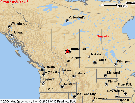 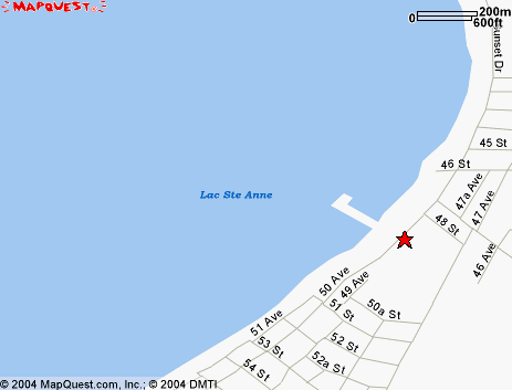 Maps from mapquest.com 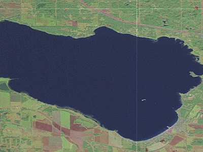 From: http://www.redtailcanyon.com/  From: http://www.albertabeach.com EDMONTON CITY CENTRE A ALBERTA Latitude: 53° 34' N Longitude: 113° 31' W Elevation: 670.60 m Climate ID: 3012208 WMO ID: 71879 TC ID: YXD Hourly Wind Speed for December 19, 2004  From: http://www.climate.weatheroffice.ec.gc.ca/ EDMONTON CITY CENTRE A ALBERTA Hourly Temperature for December 19, 2004  EDMONTON CITY CENTRE A ALBERTA Hourly Station Pressure for December 19, 2004 
__________________
FKA, Inc. transcribed by: Rick Iossi
|
|
#5
12-20-2004, 09:44 PM
|
||||
|
||||
|
Looking a bit closer at weather to the west of Edmonton (128 miles to the west), towards Alberta Beach and the direction from which the storm came from presumably.
 Alberta Beach is located between Edmonton and Edison. Weather for Edson follows: EDSON A ALBERTA Latitude: 53° 36' N Longitude: 116° 28' W Elevation: 925.40 m Climate ID: 3062242 WMO ID: 71881 TC ID: YET Hourly Wind Speed for December 19, 2004  EDSON A ALBERTA Hourly Temperature for December 19, 2004  EDSON A ALBERTA Hourly Station Pressure for December 19, 2004  Weather table for Edison for Dec. 19, 2004 http://www.climate.weatheroffice.ec....rlydata_e.html
__________________
FKA, Inc. transcribed by: Rick Iossi
|
|
#6
12-20-2004, 10:05 PM
|
||||
|
||||
|
I know very little about temperate winter weather, snow squalls or other related phenomena. I do know that traction kites will react violently to excessively gusty weather, regardless of the temperature or latitude.
If you examine the time plots of temperature, atmospheric pressure and wind speed you will readily see some obvious correlations for stations located to the west at Edson (up wind) and Edmonton (downwind) of Alberta Beach. You can go to the north and south of Alberta Beach and find very similar correlations on the interactive map page at: http://www.climate.weatheroffice.ec....onth=12&Day=19 At first glance I would say to carefully review forecasts, warnings, color radar, isobar maps** before deciding to snow kiteboard. While I was out, I would monitor sky conditions, wind speed, direction, gust range, temperature and atmospheric pressure. Many watches can currently provide temp. and pressure readouts. This would be particularly important if storms are in your area. If you are in an extended high, real time temp and press. data MAY be less important. What do others do? It looks like at least in this one case, a rapid temperature drop preceeded a violent increase in windspeed in all of the cases recorded for surrounding cities. It would be best to better understand the relationships between temperature, atmospheric pressure and the onset of squally winds. Falling atmospheric pressure seems to preceed many of these storm events, sometimes they are preceeded by a drop then a leveling off or even a rise.  From: http://www.rescuedynamics.ca/wx/canABsat.htm It would appear the leading edge of the cold front may have passed over that part of Alberta at around the time of the accident. There is an animated Sat. image page with weather symbols (front demarkations,etc.) at (great site, check it out) for around the time of the accident: http://www.atmos.washington.edu/imag...2004121921.gif Of course this was a particularly acute weather incident. I would guess that you don't need nearly as violent a gust range as happened on this date to cause a dangerous situation, just as on the water. So, you may need to look for trends and more subtle indications to improve the odds that you won't have a kite up when the strong stuff blows through. One of the newspaper accounts mentioned Lawrence normally wore a helmet but not this time. It speculated that he may have lost consciousness thereby removing his ability to depower. it is possible that the lofting/dragging happened so rapidly as to remove the option to become aware, analyze and react to the situation. We may never know but we do need to understand the various scenarios that may have transpired in an effort to reduce the odds for similar accidents. We have been focusing on weather planning and monitoring in water kiteboarding or kitesurfing for years. There isn't much difference when you are on land with regard to the threat except that there are a lot more hard objects all around on land. Weather planning and monitoring is important for any type of traction kiting. There must be a lot of accumulated knowlege among the readers in the area of ski mountaineering perhaps even winter hang gliding and paragliding. These are activities in which clear understanding, predicition and monitoring of weather have been known to be vital for a very long time. Snow kiteboarding doesn't appear to be all that different in that regard. So how about it, what can folks offer about weather planning and monitoring for areas under snow. This applies not only to plains areas but also to frozen lakes,rivers, piedmont and mountain areas, etc.. That is a lot of terrain and weather variations to address. Then again, that includes the areas we ride in. We need to accumulate information and rapidly with the explosive growth of snow kiteboarding and the season has just started. Environment Canada has some interesting looking planning resources such as the severe wx isobar maps at: http://weatheroffice.ec.gc.ca/model_...weather_e.html http://www.rescuedynamics.ca/wx/canABsat.htm Warnings at: http://weatheroffice.ec.gc.ca/warnings/warnings_e.html Text forecasts at: http://weatheroffice.ec.gc.ca/foreca...cast_e.html#AB A summary of varied wx resources for climbers in the area appears at: http://www.rescuedynamics.ca/wx/canMTNwx.htm#AB Another nice resource for the NW areas appears at: http://www.atmos.washington.edu/~ovens/loops/
__________________
FKA, Inc. transcribed by: Rick Iossi
|
|
#7
12-20-2004, 11:12 PM
|
||||
|
||||
|
I came across some good information on unstable weather hazards with a section on winter storms at: http://www.msc-smc.ec.gc.ca/educatio...weather_e.html
Some of what appears at that link is reproduced below: "Basic understandings - Winter storms Winter Storm Development 1. Winter storms are large-scale disturbances associated with low-pressure areas called mid-latitude cyclones. 2. Winds blow counterclockwise as seen from above (in the Northern Hemisphere) around the centre of the low pressure system. 3. Winter storms occur when warm, humid air interacts with colder air along the frontal boundary separating the two air masses. The two contrasting air masses provide energy, which permits the storm to intensify. 4. Winds speeds increase as the storm strengthens. The warm, moist air is lifted upward, producing widespread areas of cloudiness and precipitation along the frontal surfaces in the vicinity of the developing cyclone. 5. The normal lifetime of a winter cyclone is about three to five days. 6. Steered by the direction of the upper air flow, winter storms tend to move from west to east. Winter Storm Hazards 7. Winter storms produce strong winds, heavy precipitation (rain, freezing rain, or snow) and cold temperatures. Hazardous winter weather includes freezing rain, snow, blizzards, and bitterly cold temperatures. 8. Cold temperatures feel more extreme when there is wind. The wind chill factor combines the effect of both temperature and winds to determine the cooling rate and the equivalent temperature with no wind. 9. Environment Canada issues a variety of severe winter weather watches and warnings to alert the public to the approach of winter storm conditions. 10. Winter storm dangers include being stranded outside while exposed to the elements, having breakdowns in transportation systems due to accidents, and losing access to basic necessities and services. Narrative - Winter storms What is a Winter Storm? A winter storm is a large-scale disturbance, often hundreds of kilometres across, associated with a low-pressure system (called a cyclone) that develops along a front during the cooler part of the year. Winter storms can produce strong winds, heavy precipitation (rain, freezing rain, ice pellets or snow) and cold temperatures. What Causes Winter Storms? Winter storms occur when relatively warm, humid air interacts with colder air along the frontal boundary separating the two air masses. Initially, the front is slow-moving or stationary. The formation and evolution of a deep low pressure centre and the associated circulation is referred to as cyclogenesis. It is a complex process involving upper level divergence as well as near-surface processes. The two contrasting air masses provide energy to this rotating system, permitting the storm to intensify with time. Wind speeds increase as the storm strengthens. The warm, moist air is lifted upward, producing widespread areas of clouds and precipitation along the frontal surfaces in the vicinity of the developing cyclone. Surface map depiction of a winter storm system, showing the low pressure centre (L), cold and warm fronts, and a accompanying weather Surface map depiction of a winter storm system, showing the low pressure centre (L), cold and warm fronts, and a accompanying weather (legend gives explanation of symbols) Structure and Movement of a Winter Storm The figure (Illustration of the vertical structure of a winter storm) below displays the structure of a mature stage of a winter storm, with major features noted at both the surface and at upper levels (6 to 10 km). The primary storm is associated with the surface position of the low (L) centre and the accompanying cold and warm fronts. At upper levels, the storm normally is associated with an upper level trough, a low pressure region which forms a distinct southerly "dip" in the upper air flow, which generally lags the surface low pressure centre. The surface high (H) pressure behind the cold front brings colder temperatures, clear skies and fair weather. The entire storm system moves(arrow on surface chart labelled Movement) with the upper level steering wind currents (noted by the direction of the arrow of the jet stream). Illustration of the vertical structure of a winter storm. Illustration of the vertical structure of a winter storm. The bottom view depicts the surface features, and the top view shows upper level features of the system (adapted from Ahrens) Weather Accompanying Winter Storms Some of the hazardous weather conditions that accompany winter storms area: Heavy snow snowfalls greater than 15 cm in 12 hours usually cause significant problems. Blowing Snow wind-driven snow that reduces visibility and causes significant drifting Blizzards winds exceeding 50 km/h with snow and blowing snow reducing visibility to near zero; high wind chills. Snowsqualls narrow bands of very heavy snow that blow in off the Great Lakes, Gulf of St. Lawrence, and other bodies of water. Heavy snow and near zero visibilities are generally associated. Ice pellets raindrops that freeze before reaching the ground. This normally occurs when the rain forms along a warm front and descends through a layer of air with temperatures just below freezing. Freezing Rain rain falls through a layer or onto a surface with a temperature just below freezing, causing a layer of ice to form on the surface. Most of the hazardous weather associated with winter storms occurs in the vicinity of the low pressure centres and along the frontal systems. Warmer, moister air is lifted over the frontal systems producing widespread areas of cloudiness and precipitation. Freezing rain is often observed just ahead of the warm front, as the rain falls through colder air below. Snow occurs further north of the freezing rain area and especially in the area to the north of the cyclone where there is a deeper layer of colder air through which the precipitation falls. The prime area for blizzard conditions occurs in the immediate vicinity of the cyclone where there often is heavy snow and the strong winds rotate about the storm centre. Winter Weather Advisories and Warnings Environment Canada issues a variety of special weather statements, advisories, watches and warnings to alert the public to the approach of winter storm conditions. A special weather statement / winter weather advisory is issued when winter weather conditions are expected to cause significant inconveniences. A winter storm watch is a “heads up” that winter severe weather is expected in the near future. A winter storm warning is issued when severe winter weather conditions have begun or are about to begin in a given area. A blizzard warning is issued when snow and strong winds will combine to produce blinding snow (near zero visibility), deep drifts, and life-threatening wind chill. What is Wind Chill and the Wind Chill Index? Wind chill is the cooling effect of the wind in combination with low temperatures. When it is windy, we feel colder because our skin temperature is lower. This sensation of cold is what the wind chill index quantifies: as such, the index is not a real temperature and is expressed without units, even though it is based on the Celsius temperature scale. Environment Canada's wind chill index estimates the temperature which, with a wind of about 5 km/h, would give your face a sensation of cold similar to that caused by the actual temperature with the wind. Wind chill also estimates the risk of your getting frostbite (a severe injury caused by cold), according to these approximate thresholds: * Wind chill below -25: risk of frostbite in prolonged exposure. * Wind chill of -35: frostbite possible in 10 minutes (warm skin, suddenly exposed; shorter time if skin is cool at the start). * Wind chill of -60: frostbite possible in less than 2 minutes (warm skin, suddenly exposed; shorter time if skin is cool at the start). Chart of Wind Chill. Major Health Hazards The major health problems associated with winter storms are overexposure and overexertion. Overexposure implies that parts of the body are not properly protected from the cold temperatures and/or strong winds, leading to frostbite or hypothermia. Overexertion results from the strain of working too hard in cold temperatures, and can lead to heart failure." There are some good graphics in that article that are worth reviewing directly.
__________________
FKA, Inc. transcribed by: Rick Iossi
|
|
#8
12-21-2004, 01:41 AM
|
|||
|
|||
|
A personal account of this storm:
This particular storm was very hard to predict, there was a wind warning issued in the area but not until after the front had passed and the damage already done. For that afternoon Enviroment Canada (www.weather.ec.gc.ca) was forecasting winds building to 40 gusting to 60km/hr in the afternoon. The weather network (www.theweathernetwork.com) was predicting winds building to 45km/hr later in the evening. I stepped onto a lake slightly south east of Edmonton at around 11:30 that morning. The temperature was very mild and warming quickly. A quick scan of the horizon revealed mostly blue sky with a thin but dark band of clouds far to the north and west. The wind was blowing from the south west at around 25km/hr. Just prior to arriving at the lake I recieved a call from a fellow kiter who was on his way. He reported that he had talked to a friend from Lake Wabamun who's camper had been blown over by the wind a few minutes ago. Lake Wabamun is slightly south of Where Lawrence was killed. Again, scaning the horizon there was no indication of a severe weather event anywhere nearby. This is very flat country, usually you get half an hours warning or more when any wierd weather approaches. I decided to launch a kite. Immediately, when my kite was in the air I could tell that the wind was wierd. It was very gustly and swirly for the relatively low wind velocity. On a few occasions the kite would fly beyond me by 10 degrees or more or get pushed straight vertically towards the ground. I atributed this behaviour to a stand of trees some 400-500 meters upwind and decided to head farther onto the lake seeking cleaner wind. 250 meters onto the lake with no obstructions upwind for 2-3 kilometers the wind was no better. I returned to the truck and landed my kite. Scanning the horizon again northwest of my location the sky had become very dark and smudged. There seemed to be a huge dusty streak across the sky, I estimate about 20km away. The cloud was becoming ominous but was still relatively distant. Another kiter arived at the lake as I was securing my kite. He reported that there was a major wind storm west of us and we should pack up immediately. I asked him to pack up my kite as I ran onto the lake to warm the local kite shop owner who had two trainer kites flying with a group of new kiters. I estimate from this moment we had one minute or less before the wind hit. By the time the trainers were on the ground and I returned to the truck the wind speed increased almost instantly from 30km/hr to upwards of 100km/hr. There was almost no warning, no temperature change at all. Until it was blocked out by the blowing snow and dirt the sun was still shining. If you had the misfourtune of having a kite in the air at that moment, I don't know how much of a chance you would have unless you could release your kite imediately. This was a freak weather ocurence in the area. That afternoon was the highest sustained wind velocity recorded in the area ever and tied for the highest gust velocity. Had the snow conditions been better on the lake or had the storm hit later in the day there would have been many more kiters riding in the area.
|
|
#9
12-21-2004, 10:03 AM
|
||||
|
||||
|
Quote:
Thank you for the detailed observations. They help a lot. Do you know where the kiter that warned of a pending storm received that information from? Looking at the Environment Canada wind data it looks like a warning could have been generated from points west as there was about an hour or more time lag. I agree, this was one extreme weather event and likely a fairly rare one too. Still, I wonder about the hazards posed by less dramatic gust events. We know a fair amount about gusts on the water and kiteboarding accidents. It seems what constitutes "excessively gusty" conditions is still coming into focus across the sport worldwide given the series of tragic kitesurfing accidents in the last few months in squalls. What is considered "excessively gusty" winds in snow kiteboarding? This will vary from individual to individual but it would be good to know. Also, what factors do you look for before and during a session regarding unstable weather? Thanks,
__________________
FKA, Inc. transcribed by: Rick Iossi
|
|
#10
03-08-2005, 05:40 AM
|
||||
|
||||
|
I just came across an indepth weather analysis of the December 19, 2004 storm event complete with a time plot of wind spikes vs. location, damage, radar images and surface photos.
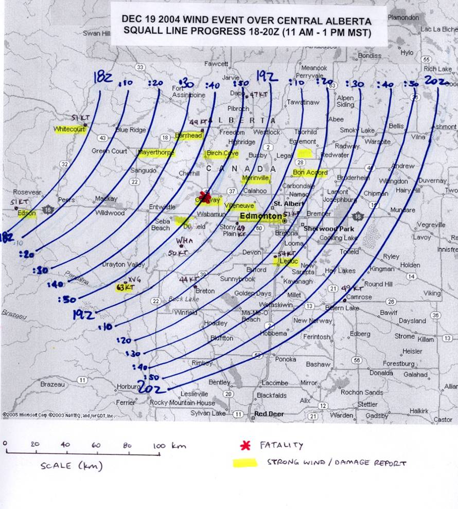 The time series (From**) 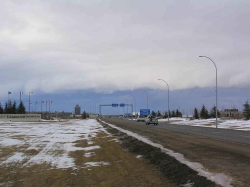 This system generated some dramatic shelf clouds, often assoicated with violent weather (from**) ** For more info: http://www.umanitoba.ca/faculties/en...torm/main.html
__________________
FKA, Inc. transcribed by: Rick Iossi
|
 |
|
|


 Linear Mode

