|
#1
 07-08-2010, 11:55 AM
|
||||
|
||||
 Lots of fish schools over the jacks, perhaps even more than on the Dania groin. Back in the 1960's the Erosion Prevention District constructed two submerged groin structures with the intent of inhibiting long shore transport and loss of sediment from beaches. The northern 825 ft. long erojack structure was constructed about 1.2 miles north of Port Everglades Inlet. It extends from about 1/3 mile east from the jetty remains on the beach to the second reef terrace and a western facing ledge about .4 miles offshore. It crossed a sand channel with the intent of inhibiting sand flow which it apparently failed to do in substantial measure. The concept may have originally been developed for using erojacks to form jetties and breakwaters. For folks that grew up diving in the area, there is more than a little history attached to these almost 50 year old structures. 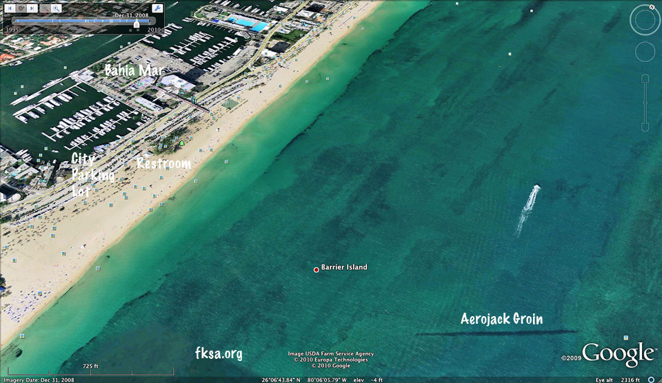 Shows up well in the satellite image from this year. Can even make out the sand channel and inner/outer reefs. They used to have iron forms over in Port Everglades for casting these jacks. There are some circular aerojack reefs off Sunrise Blvd. in about 60 ft. of water as well. A sand tracer study was done in the 1970's which indicated most sand would readily pass over time through the structure.  It appears on the Maptech chart as Submerged Groin. Water depths along the structure are typically on the order of 15 ft.. The jacks attract a considerable quantity of marine life. Even though the concrete comprising the jacks has had superlative longevity with next to no spawling or delamination cracking there has been limited coral growth. There are some hard corals growing on the jacks, soft tissued zooanthids, sea fans, bryozoans and crustose algae. 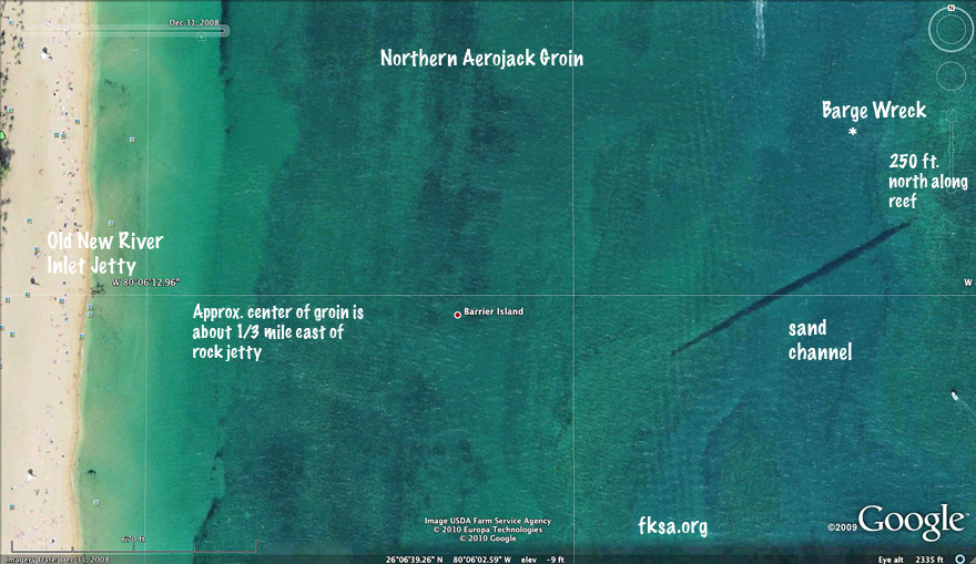 A closer look at the layout of things. For safety and convenience most come to the aerojack reef by boat. This is what the Ft. Lauderdale Beach Patrol has to say about diving off the beach. "7.2 Skin and scuba diving shall be permitted from the Fort Lauderdale Beach under the following regulations: 7.2(a) All divers must be accompanied by at least one other diver. 7.2(b) Each diver is equipped with a buoyancy compensator. 7.2(c) Divers must have an approved diver's down flag displayed in accordance with Statutes of the State of Florida. 7.2(d) Scuba divers must remain a minimum of 100 yards offshore, except when entering or leaving the water. 7.2(e) Divers using mask, snorkel, and fins within 50 yards are permitted and are considered bathers. If skin divers desire to go beyond 50 yards, then all other requirements of Rule 7.2 applicable to scuba divers must be met. 7.2(f) The use or possession of spear guns or similar weapons is prohibited on the beach. Such weapons may be transported via legally launched watercraft to a minimum distance of 150 yards offshore. During such transportation, weapons must be handled safely in an unarmed condition. 7.2(g) Scuba instruction by private enterprise is prohibited. 7.2(h) Scuba entry through the designated boat launching area(s) or surfing area(s) is prohibited." http://ci.ftlaud.fl.us/oceanrescue/rules.htm 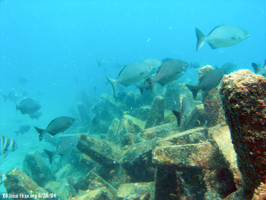 Fish do like the jacks even if sand sort drifts on by. A raw video clip of the jacks from a while back.* 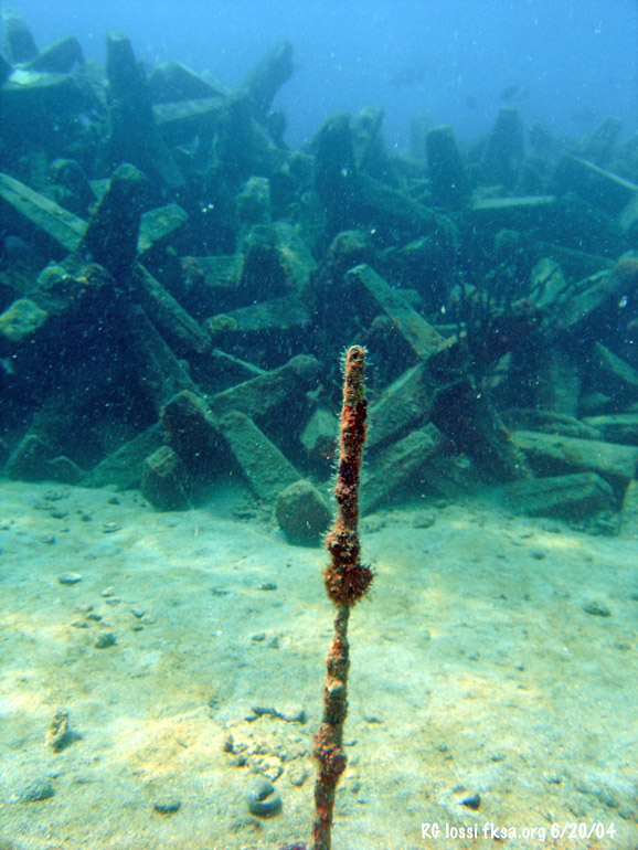 I think this is one of the steel rebar stakes I drove into the rock bottom for a sand transport survey when I was 18. I recall some nasty cold rough winter diving conditions but when you gotta work, you gotta work. Did it through Ocean Reasearch & Survey with Bill Raymond, Greg McIntosh and George Doyle. We did several other reef surveys including some damage assessments, UW cine & photogrammetery, fisheries and artificial reef work later on, UW archaeology projects shipwrecks and an early man sulphur spring site, getting the first not-for-profit shipwreck exploration permit from the Div. of Archives, even some stuff in Haiti involving what was thought to have been Columbus' Santa Maria sunk five centuries before and lots more. Fun times. 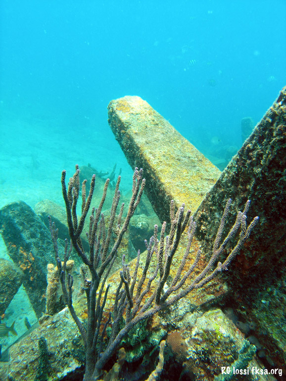 The area is subject to strong currents related to tides and Port Everglades and to the Florida Current. Either of these factors can cause currents to run north or south, even east at times too! As a rule of thumb, clearer water may be had with lighter current, MAYBE, around high tide. A massive river of brown tannin rich water floods out of Port Everglades with each low tide. It can travel for many miles north or south and to hundreds of feet in depth depending on prevailing conditions. There have been times when brown water from Hillsboro Inlet traveled south to meet the same moving north from Port Everglades in opposing currents?! Having spent way too many hours doing commercial work in the Intracoastal, I prefer clear water as opposed to brown. Spend some effort trying to avoid it too. It is even better when the advancing curtain of brown water comes adorned with shredded toilet paper, plastic bags, etc.. Why dive in poopy water if you have a choice? 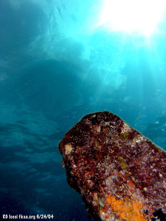 So, try to dial in clearer water if you can, or ... 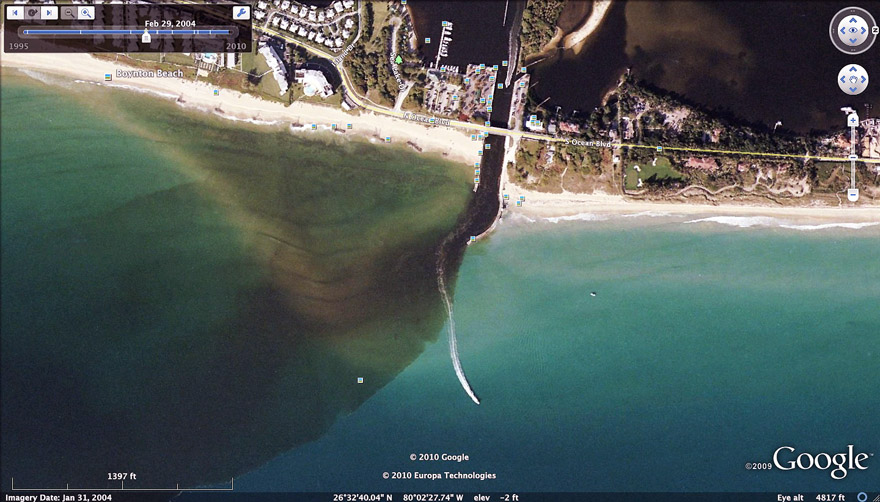 Slide into some of this brown stuff. The photo run happened to catch this south running arc of tannin and (?) stained water flowing out of the ICW through Boynton Inlet. Sometimes it goes south and sometimes north, even both to a degree at still other times. Being so close to the main inlet for Greater Ft. Lauderdale there can be a LOT OF BOAT TRAFFIC through here. Some operating under the influence, some without a clue, both or merely not paying careful enough attention. Would recommend avoiding peak boat times on this reef. Don't want to read about anyone being hit out here. It is best to listen for boats underwater and if you hear one and you're on the surface, locate it pronto and see if it is coming towards you. If so, it should veer off before coming too close to your flag. If not, submerge fast well below striking depth if on SCUBA otherwise try splashing to get their attention. Nice to have your big boat nearby anchored to help ward off some of these idiots. 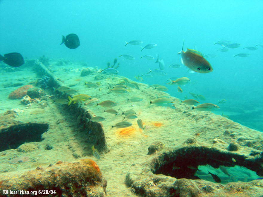 There are the remains of a riveted barge wreck about 250 ft. north along the western face of the outer reef at the eastern end of the aerojack groin. The bow is still somewhat intact but the rest was blasted to flat plates on the bottom. Not sure about how it ended up here but from the construction I would guess it is old. Old enough perhaps to have sunk off the old New River Inlet due west of here. One of the rock jetties still shows up on the beach. This was before Port Everglades existed with a small cut to Lake Mabel (now Port Everglades) and Whiskey Creek being the next inlets to the south in Dania. The horrific hurricane of 1926 filled in the New River Inlet. It destroyed a lot more than that throughout the area. It even made a 500 ft. long mangrove cay off Dania vanish. Wonder if the Hurricane of 1926 took the barge out as well? Once found an old set of brass binoculars in a hole in the reef near here. They may have been from the late 1800's or early part of the last century. A yachty or perhaps a child dropped them overboard a long time ago off the old inlet. All boat traffic used to go right through this area.  From: http://www.broward.org/ Things just before the hurricane in 1925. The inlet and New River are up there to the north with parts of early Ft. Lauderdale. That mangrove cay off Whisky Creek on soon to be Dania Beach vanished in the hurricane. That's Lake Mabel just to the west and the former New River Inlet near the north end of that sand bar. Being doing just a little dredge and fill here since, what do you think?  For something a little different for this neighborhood, checkout: http://www.fksa.org/showthread.php?t=8215 http://www.fksa.org/showthread.php?t=8615 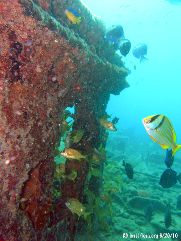 Another thing that is good to keep in mind during the cooler months, the Portuguese season, is to keep looking updrift for man-o-war floats. They seem to be more prevalent near shore during NE to E winds bringing the Florida Current closer in and blowing the floats landward. They can show up in more southerly winds too, just in lessor numbers at times. If it isn't too ragged out with chop and foam they should show up somewhat. If you're free diving this is a must do every time you surface and while you're up top. Remember man-o-war can have real long tenticles, 30 ft. or more when you are trying to avoid them. Worse, sometimes they can nail you while you're submerged, not much you can do to avoid it in that case. 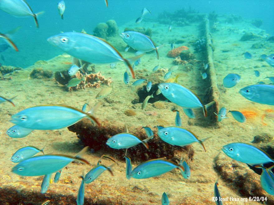 Fish like the wreck, with glassy eyed sweepers hanging out inside the hull. 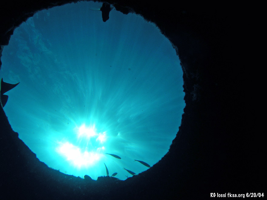 The big smurf in the sky. 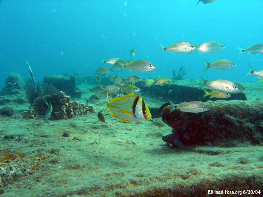 A raw video clip from the barge.* * Sorry about the poor youtube image compression quality. I'll put something up on Vimeo that should be clearer soon! 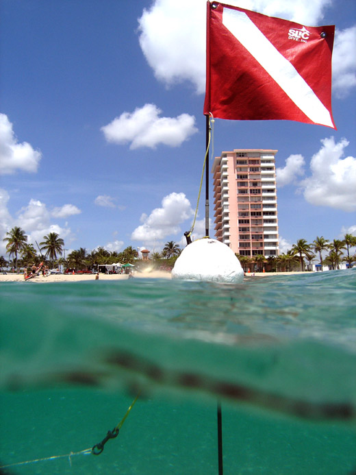 Heading to shore, good times. Another spot down, more to go. NOTE: You can be severely injured or killed diving even if you comply with the following. Proper training, certification, conditioning, careful experience development and following proper safe diving practices are essential. Beach diving may present additional stresses and hazards particularly when compared to boat dives. As such beach diving isn't suitable for everyone. Always dive well within your abilities following proper diving safety practices. Copyright FKA, Inc. 2010 All Rights Reserved .
__________________
FKA, Inc. transcribed by: Rick Iossi Last edited by ricki; 07-09-2010 at 01:38 PM. 
|
|
#2
07-09-2010, 05:46 AM
|
|||
|
|||
|
Nice Building there on the shore !

|
|
#3
07-09-2010, 05:53 AM
|
||||
|
||||
|
Hey Eric, can you see the aerojack reef on a clear day, it might show up pretty well? Nice view you have up that way. I have some great cloud EVO shots from your beach from last week, been meaning to process and put them up.
__________________
FKA, Inc. transcribed by: Rick Iossi
|
|
#4
07-09-2010, 08:38 AM
|
|||
|
|||
|
|
|
#6
07-12-2010, 10:14 AM
|
||||
|
||||
|
How to find the jacks and barge? As recent experience has shown, they can be hard to find at times! Range marks should fix that.
If you have a boat with a GPS, you should be able to head to these coordinates. You can check this on google earth. Nearshore end of Erojacks: 26 06' 37.21" N, 80 05' 57.17" W Barge wreck: 26 06' 44.40" N, 80 05' 50.55" W If you don't have a GPS, you can use the following range marks: 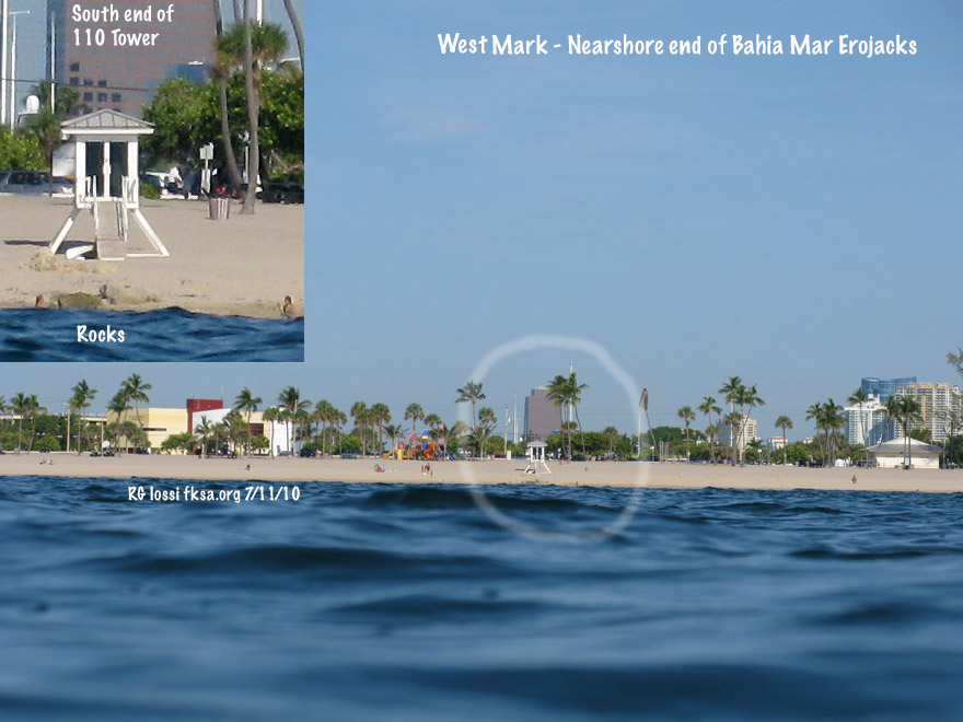 The west mark for the nearshore or western end of the Erojack groin. Line up the former New River Inlet jetty remnants with the south side of 110 Tower. As long as they don't move the lifeguard tower you can use that too but there's a good chance it will be moved. This takes you to the eastern edge of a small reef ledge that drops into the sand channel. You could run out or in on this mark until the north mark intersects. You could track the south mark too but it is less senstive (accurate). 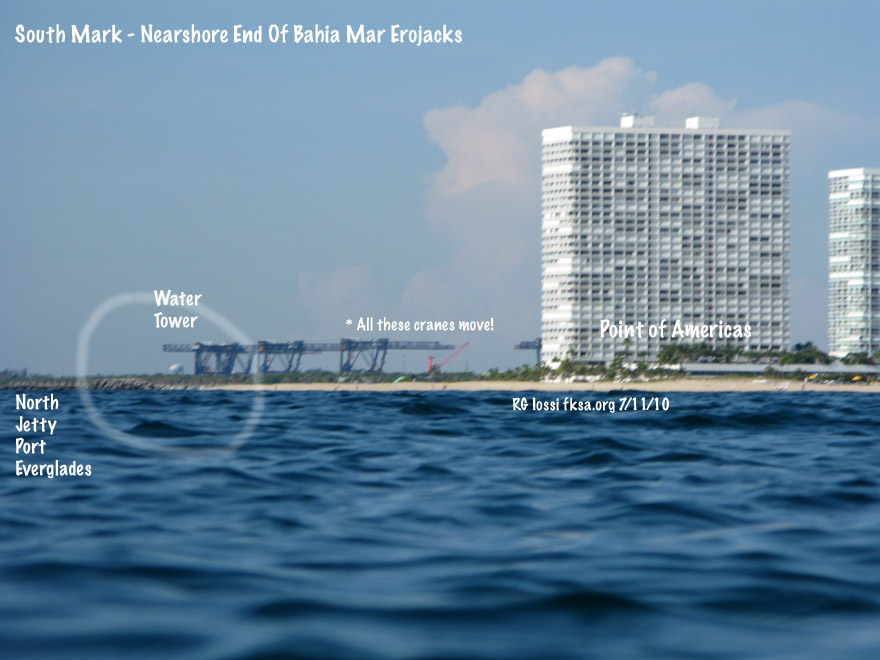 The south mark for the nearshore or western end of the Erojack groin. Try to place the water tower over the western portion of the north jetty to Port Everglades. Thought the container cranes would make nice range points, trouble is they're on tracks and can move a lot! This is a less sensitive range mark than the western or northern marks.  The north mark for the nearshore or western end of the Erojack groin. Just line up the western edge of the building with the third roof feature of the Portofino (?) condo over by Sunrise Blvd.. Copyright FKA, Inc. 2010 All rights reserved.
__________________
FKA, Inc. transcribed by: Rick Iossi Last edited by ricki; 07-12-2010 at 10:34 AM.
|
|
#7
07-12-2010, 10:19 AM
|
||||
|
||||
|
An overview of the layout of things. Here are the range marks for the barge wreck. The wreck is about 335 ft. north of the jacks on a west facing low reef ledge. This ledge is about 75 ft. west of the seaward end of the Erojack groin.  The west mark for the barge wreck. Just line up the south edge of the Bahia Mar tower with that roof feature of the Sunsentinel building downtown.  The south mark for the barge wreck. Just line up the water tower over the end of the Port Everglades jetty. This mark along with the west mark should drop you right on the barge.  The north marks for the barge wreck. There are two intersections for this one as noted with the "*." 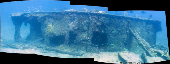 Just aft of the barge bow looking west. Click photo for full sized image. Copyright FKA, Inc. 2010 All rights reserved
__________________
FKA, Inc. transcribed by: Rick Iossi
|
|
#8
08-01-2010, 10:17 PM
|
||||
|
||||
|
A short segment scooter free diving over the jacks at night a few days ago.
Lots of amorous trumpet fish?! p.s. - shot this with a $105. 400 lumen movie light along with my Canon G9? So, the framing is shaky being hand held while free diving. Could be improved using a mounting arm and a diffuser (white plastic cover) over the light. Maybe go nuts and even use two Princeton Tech Shockwave LED UW lights. Sure beats paying $800. + for a movie light at any rate.
__________________
FKA, Inc. transcribed by: Rick Iossi
|
 |
| Thread Tools | |
| Display Modes | |
|
|


 Linear Mode

