|
|
|
#1
 09-06-2017, 09:49 PM
|
||||
|
||||
|
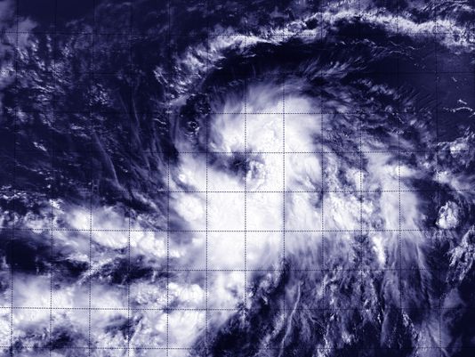
I have updated and added some new links in response to this horrific storm on the first page of this thread. Good luck with Hurricane Irma, stay safe out there.
__________________
FKA, Inc. transcribed by: Rick Iossi Last edited by ricki; 09-07-2017 at 05:12 PM. 
|
|
#2
08-18-2015, 08:07 PM
|
||||
|
||||
|
I had hopes for an uneventful tropical weather season. It could still happen but for now it looks like we may have a hurricane heading into our region soon. TD Danny was designated as a tropical storm today as it crosses the Atlantic from the Cape Verde Islands. It is showing good signs of organization and is anticipated to strengthen.
 http://www.wunderground.com/hurricane/ It is forecast at the present time to become a low grade hurricane Thursday afternoon.  Shea Gibson and the folks at WeatherFlow/WindAlert have assembled this graphic for the storm. More at: http://www.windalert.com and https://www.facebook.com/groups/Chuc...eport/?fref=nf  http://www.nhc.noaa.gov/graphics_at4...daynl#contents Pulling out the digital Ouija board, one long range GFS forecast path shown below for the center of the storm, has it crossing over Guadaloupe late on August 24th.. Then it is forecast to pass over Puerto Rico. These are very long range projections with a lot of uncertainty and MAY NEVER HAPPEN, or they might. Best to consider it a wake up call for now and not much more for South Florida at this time. 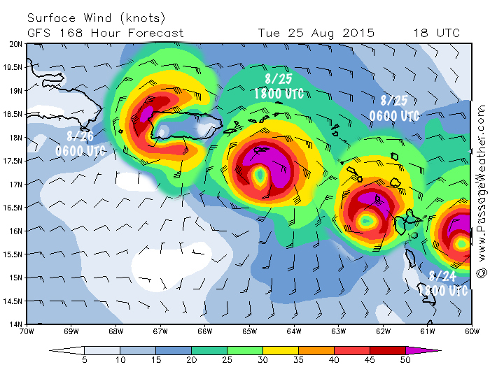 Assembled from GFS model projections on http://passageweather.com/ and may be nothing more than colorful fiction or not. Time will tell. There is an excellent video analysis of the storm and future prospects at: http://www.tropicaltidbits.com/blog/...e-a-hurricane/ It is likely it may play out differently but how differently is unknown, stronger, weaker, by a different path and time, etc.. With luck some dry air and wind shear will weaken the system. So it goes with tropical weather. This is what Dr. Jeff Masters of the Weather Underground has to say about it currently: "Most of the dynamical track models now move Danny toward the west-northwest at a fairly modest pace until this weekend, when a building ridge to the north should help push it at a faster rate. By that point, Danny would draw on oceanic heat content that gradually increases along its path. However, a large area of dry air and Saharan dust north of Danny may inhibit its development at times. With a solid convective core, Danny might be able to fend off interference from this dry, dusty air until it encounters pockets of stronger wind shear, a possibility that long-range models are suggesting for this weekend into early next week. Thus, there is no guarantee that Danny would maintain whatever strength it attains in the deep tropics, and it is still far too early to predict with any confidence how much of a threat Danny might pose to the United States if it survives the long trek. A small change in trajectory now would have big implications for the track many days from now. " More at http://www.wunderground.com/blog/Jef...?entrynum=3076 It is possible we might have some tropical weather to deal with in South Florida in the later part of next week, or not. 'Tis the season, check your supplies, preparations and hope the season goes to sleep despite your precautions. Take care.
__________________
FKA, Inc. transcribed by: Rick Iossi Last edited by ricki; 08-18-2015 at 08:50 PM.
|
|
#3
08-20-2015, 10:10 AM
|
||||
|
||||
 http://www.nhc.noaa.gov/ Danny is now a minimal hurricane heading slowly to the WNW, towards us. It is forecast to weaken back to TS status after passing over the Antilles and then … we'll see.  Forecast track and intensities from: http://crownweather.com/
__________________
FKA, Inc. transcribed by: Rick Iossi Last edited by ricki; 08-20-2015 at 10:26 AM.
|
 |
|
|


 Hybrid Mode
