|
#1
 08-30-2006, 02:29 PM
|
||||
|
||||
|
Earlier this morning as a result of TS Ernesto there was about an 87 kt. gust spike in east Boca Raton at close to 9 am. This was recorded at: http://www.evsboca.com/
 The refectivity radar image for the area (very close to "BCT" at the SE corner of Palm Beach county) was unimpressive to say the least.  BUT, checkout the velocity image:  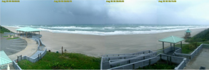 CLICK FOR FULL SIZED IMAGE A composite image taken from the hi res EVS livecam at the anenometer station at 9:08 am following the wind spike appears above. There seems to be a particularly dark cloud mass moving to the NE of the location. 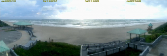 CLICK FOR FULL SIZED IMAGE The image from the archive before the one shown above is from 8:18 am. I would strongly recommend that kiters checkout both reflectivity and velocity images when weather planning for sessions. Remember just because something is inbound doesn't mean it will necessarily arrive or won't be replaced by something equally serious at a different time. NWS radar is available for your area at: http://www.nws.noaa.gov/ You can click on the images to zoom in closer. More about these images and interpretation at: http://www.srh.noaa.gov/jetstream/re...velocityimages
__________________
FKA, Inc. transcribed by: Rick Iossi 
|
|
#2
08-30-2006, 06:42 PM
|
||||
|
||||
|
Hmmmmm
I wonder how much the velocity radar actually plays a hand w/o storm activity velocity looked bad here in tampa but storm looked good from 1-4pm ( thats the hole in the feeder bands you look for ) riding all afternoon w/o a sign of any squalls till 5 pm ( now its raining again......)
|
|
#3
08-30-2006, 06:45 PM
|
||||
|
||||
|
impressive,
indeed, we shall all be aware that there is no final say to the weather.... nice stuff rick -Danny
|
|
#4
09-01-2006, 09:07 AM
|
||||
|
||||
|
I just found some archived livecam images from around the time of the wind gust from the anenometer station, http://www.evsboca.com/ . They have been added to the account above. You can make out something of the clouds moving across particularly in the full size image. These clouds were slightly darker than everything else that was blowing through but perhaps not remarkably so. It may have been a shelf cloud but it is hard to tell from the image.
Guys were riding 6 miles north in Delray at the time. There also might have been guys out to the south in Pompano and Ft. Lauderdale. I imagine if they were hit by a 87 kt. gust, even if they were rigged for winds in the 40's the outcome would likely be grim. There is a private anenometer in Delray that stayed at around 45 kts. around the time of this event. Nothing remarkable showed up at the next anenometer about 10 miles to the south at Ft. Lauderdale Executive AP. I wonder if this might have been a microburst? There have been past indications of microbursts in this area at one, perhaps two other times. NOTE: there was a lull in the wind record before the big gust spike. This happens sometimes as was the case on August 8, 2006. More at http://fksa.org/viewtopic.php?t=2375 The wind eased off, one guy came in to rig a larger kite despite obvious storm conditions moving in and without any knowledge of what was on the radar. Others have done this in the past, ignoring what may be a good indication of much stronger winds to come. There isn't always a lull however, only sometimes before major gust spikes. I have been looking in on the radar velocity images and ikitesurf realtime windspeeds off the Carolinas as Ernesto moves north. Sometimes the radar agrees with the realtime wind speeds and other times not. It does make you wonder.
__________________
FKA, Inc. transcribed by: Rick Iossi
|
|
#5
09-01-2006, 10:06 AM
|
||||
|
||||
|
So, what do you think is going on here? Was it just an isolated gust front perhaps associated with a shelf cloud? Was it a microburst? How useful are doppler radar velocity images in predicting strong wind gusts associated with storms/squalls? Other ideas, insights or comments are welcome.
Thanks!
__________________
FKA, Inc. transcribed by: Rick Iossi
|
 |
|
|


 Linear Mode

