|

|
||||||
 |
 |
|
|
Thread Tools | Display Modes |
|
|
|
#1
 05-15-2010, 02:25 PM
|
||||
|
||||
|
SERT Gator, a powerful visualization tool of threat, weather and response
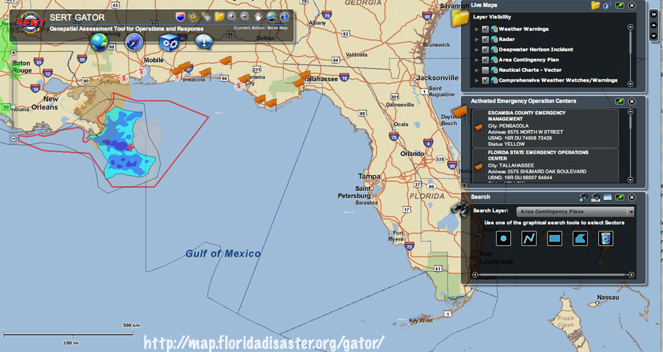 Located at http://map.floridadisaster.org/gator/ The State Emergency Response Team (SERT) have created this nice webpage integrating oil plume, weather and other data, emergency response by sector, search functions and a good deal more on an interactive map platform. Or, in bureau geek-speak: "Flex Viewer to demonstrate the best practice to develop GeoWeb application by leveraging the power of spatial technologies." Click on the earth icon beneath the title to convert it to a satellite map. It was created to deal with emergencies in general, so hurricanes, floods, droughts, fire, etc., you can check them out here and resources to go with. Lots of interesting features on this! More at: http://www.floridadisaster.org/eoc/update/home.asp and You can see some of this same stuff yourself on google earth. Just click on this flame icon off New Orleans and a window will pop up with several links. It will show you things like size, proximity and landfall of the oil plume: 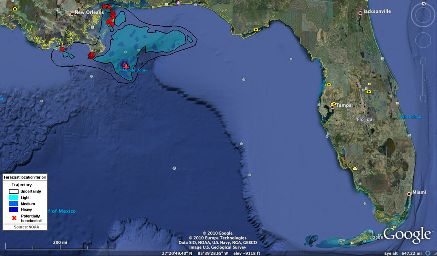 and 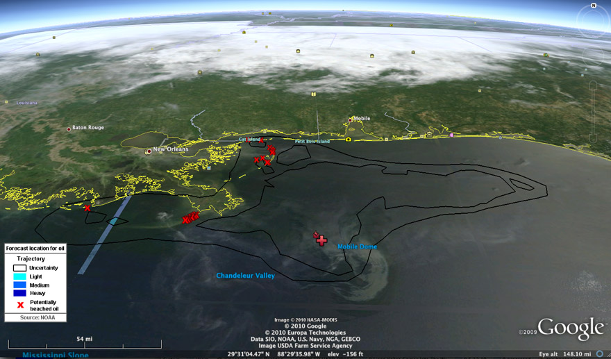 Actual fairly recent satellite imagery of the plume. This is from May 8, 2010. Note the wispy colored features around the release point and extending west, east and north. That is the oil plume.
__________________
FKA, Inc. transcribed by: Rick Iossi Last edited by ricki; 05-16-2010 at 12:22 AM. 
|
|
#2
05-16-2010, 04:41 PM
|
||||
|
||||
|
"Scientist: Oil may be entering Gulf Loop current, could reach Palm Beach County
Oil may be on its way. New satellite images show oil starting to enter the Gulf Loop current, which would pull it through the Florida Keys, into the Gulf Stream and up to Palm Beach County, according to a scientist tracking the oil spewing into the gulf. The new images, taken Saturday by NASA's Jet Propulsion Laboratory, "clearly [show] that the oil is being pulled into the Loop current," according to a release from Mitch Roffer, an oceanographer who runs Roffer's Ocean Fishing Forecasting Service and has been providing daily updates on the spill's movement. "We still don't know how long it's going to take to get around to the Keys and then the east coast of Florida - it just remains to be seen," Roffer said Saturday. That process, which is difficult to predict, would take at least a week, and possibly several, scientists say." Continued: http://www.sun-sentinel.com/news/pal...,7727606.story "ROFFS™ OCEANOGRAPHIC ANALYSIS FOR THE DEEPWATER HORIZON OIL SPILL AREA UPDATED SATURDAY 15 MAY 2010 (16:00 HRS) See enclosed PDF analysis as the graphic is enclosed. Higher resolution graphics are available. We received some dramatic and clear synthetic aperture radar (SAR) imagery from the NASA Jet Propulsion Laboratory (thank you Ben Holt) that clearly shows that the oil is being pulled into the Loop Current. The first two images are from today and the third and fourth one is from May 12, 2010. I have annotated the imagery so you can see the oil. On the image from May 12, one can also see the tendrils of oil that have moved west and southwest. These images confirm again our water mass– sequential image analysis technique that we have been using. See the analyses from earlier this week on other evidence of this. Obviously the oil has moved further into the Loop Current system than we had seen the last few days using infrared, ocean color and RGB satellite data. The question now is how fast and how much of this oil will be entrained into the Loop Current.The other critical questions are what is below the slick and what is in the water masses we have been tracking since the original spill? What will we do to stop the impacts of this oil and the other oil moving along the northern Gulf of Mexico." Continued at: http://www.roffs.com/DeepwaterHorizo...il15May10b.pdf 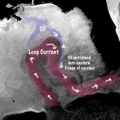 JPL Imagery via Roffs. Labeling and highlighted areas have been added to aid clarity. You can see static and animated JPL sat. imagery of the Gulf, oil plume and Loop Current at ROFFS website where the plume appears to merge with the Loop Current at: http://www.roffs.com/deepwaterhorizon.html The animated imagery shows what appears to be the entrainment of the oil plume more clearly than the image above.  More Roffs imagery from earlier in the month. From: http://www.marlinmag.com/news/news/r...000082714.html Information was not provided regarding quantities and nature of the floating component of the spill that may be transported into the Straits of Florida. What near term impacts that may be experienced in these areas, if any, particularly closer to shore will be controlled in part by these factors and local weather/current conditions. Roffs previously monitored transport of oil spills created by Hurricane Katrina via the Loop Current into the Straits. .
__________________
FKA, Inc. transcribed by: Rick Iossi Last edited by ricki; 05-19-2010 at 04:06 PM.
|
|
#3
05-17-2010, 08:57 PM
|
||||
|
||||
|
A NOAA document for - Oil Spills in Coral Reefs: Planning and Response Considerations
http://tinyurl.com/coralreefresponse This 2001 report summarizes relevant research on coral reefs. It was written for spill response decisionmakers and anyone working in or planning for spill response in coral reef regions. Oil Spills in Coral Reefs is the first in a series of publications prepared by NOAA's Office of Response and Restoration (OR&R) to provide response-related information on specific warm-water resources. * Title Page, Table of Contents, Introduction * Chapter 1, Coral Reef Ecology Introduces pertinent aspects of the coral ecosystem. * Chapter 2, Global and Local Impacts Summarizes the environmental impacts on coral from human and natural causes. * Chapter 3, Oil Toxicity to Corals A current review of the research available on oil toxicity to coral. * Chapter 4, Response Methods for Coral Reef Areas General guidance for responding to spills in coral reefs and specific considerations for open-water cleanup measures. * Chapter 5, Coral Reef Restoration Discusses the emerging science of restoration of damaged reefs, and presents data on recovery patterns and rates from a variety of impacts in coral habitats. * Chapter 6, Coral Case Studies Several case studies that illustrate a range of issues, including the new technologies being used to restore coral reefs. * Glossary * Coral Websites A list of websites that provide useful data on reefs. * Coral Reefs: Spills and Other Threats AND a response document for mangroves and oil spills at: http://tinyurl.com/mangroveoilresponse .
__________________
FKA, Inc. transcribed by: Rick Iossi Last edited by ricki; 05-18-2010 at 02:18 PM.
|
|
#4
05-18-2010, 02:00 PM
|
||||
|
||||
|
REAL bad news if this is from the spill in the Gulf.
 Tar balls retrieved from Fort Zachary State Park in Key West, Fla., is shown Monday, May 17, 2010, in this photo released by the U.S. Coast Guard on Tuesday, May 18, 2010. "Coast Guard investigates reports that more tar balls found in Florida Keys KEY WEST The Coast Guard was checking reports that more tar balls were found in the Florida Keys on Tuesday, a day after 20 of them were found off Key West. Tar balls were reported on the beach in Big Pine Key at 8 a.m., Smathers Beach in Key West at 8:20 a.m., and on Loggerhead Key in the Dry Tortugas National Park at 9 a.m., according to the Coast Guard. Twenty tar balls were found off Key West on Monday. They are being tested by the Coast Guard to see if they came from the Gulf of Mexico oil spill or elsewhere. Tar balls can occur naturally or come from other sources, such as ships. The Coast Guard said the Keys beaches remain open. Crews are checking the shorelines of Key West and Big Pine Key, and a helicopter is surveying the scene from the air. University of South Florida scientists are forecasting that oil from the spill off Louisiana could reach Key West by Sunday. The researchers said Tuesday that the southern arm of the massive spill has entered or is near the so-called loop current, which circulates in the Gulf and takes water south to the Florida Keys and the Gulf Stream. The Gulf Stream could eventually take the oil up Florida's Atlantic coast. Jane Lubchenco, administrator of the National Oceanic and Atmospheric Administration, says aerial surveys show some tendrils of light oil close to or already in the loop current. But most of the oil is dozens of miles away from the current. Lubchenco says it will take about eight to 10 days after oil enters the current before it begins to reach Florida. The Coast Guard reported that Monday's tar balls were found along the shore at Fort Zachary Taylor State Park in Key West. Samples of the tar balls — found by park rangers and ranging in size from 3 inches to 8 inches in diameter — will be sent to a Connecticut laboratory for analysis, according to the Coast Guard." Continued at: http://www.sun-sentinel.com/news/loc...,2331747.story and  "Park rangers discovered 20 ''tar balls'' on a Key West shore and spotted oil residue farther west in the Dry Tortugas Tuesday, stirring fear that the first sign of the massive BP oil spill had washed up on a Florida shore. The Coast Guard urged calm and sent samples of the three- to eight-inch flattened tar balls for lab analysis in Groton, Conn., to determine whether the hazardous waste was from the massive leak in the Gulf of Mexico or perhaps oil remnants from a passing ship. ``There is no proof or reason to believe these tar balls are from the Gulf at this point,'' said Coast Guard Lt.j.g. Anna K. Dixon, adding that analysis of the tar balls' origins would not be complete before day's end. Still, the discovery stirred fears of a financial fallout -- stoked all the more by a fishing ban in 19 percent of the Gulf of Mexico, plus a grim new tracking map that graphically predicted a black oil slick encircling the Florida peninsula in 10 days. ``While I always hope for the best, this is looking like really out-of-control bad,'' Florida Democratic Sen. Bill Nelson said about fresh research by the University of South Florida College of Marine Science in St. Petersburg. The team predicted the Deepwater Horizon's slick would reach the Keys by this weekend -- and Miami next week. In the Keys, however, a midday survey found a second ``oil residue'' sighting at Loggerhead Key in the Dry Tortugas, said Larry Perez, information officer for Everglades National Park. Loggerhead is home to a well-known lighthouse in the popular if remote tourist destination -- about 70 miles west of Key West and far closer to the Gulf of Mexico. Perez said a U.S. Coast Guard team was flying to the island to inspect the shoreline. It was not immediately known when the oil residue was spotted, or whether it was the kind of tar balls found at Fort Zachary Taylor. Read more: http://www.miamiherald.com/2010/05/1...-over-tar.html " Roffs identified oil spill plume by the loop current in satellite imagery as far back as 2 weeks ago. That might explain the arrival of tar balls around now. More at: http://www.marlinmag.com/news/news/r...000082714.html
__________________
FKA, Inc. transcribed by: Rick Iossi Last edited by ricki; 05-18-2010 at 07:01 PM.
|
|
#5
05-19-2010, 08:10 AM
|
||||
|
||||
|
Some good news,
"KEY WEST The Coast Guard announced this morning that that blobs of tar that have washed up on the Florida Keys this week are not related to the Gulf oil spill. The Coast Guard set to work analyzing blobs of tar that washed up on the Keys on Monday and Tuesday, as evidence mounted that at least some oil from the Gulf spill soon would be in South Florida. The analysis determined conclusively that the tar balls collected from the Keys beaches do not match the type of oil from the Gulf spill, the agency announced in a press release. The source of those tar blobs is unknown. "The conclusion that these tar balls are not from the Deepwater Horizon oil spill incident in no way diminishes the need to continue to aggressively identify and clean up tar ball-contaminated areas in the Florida Keys," said Capt. Pat DeQuattro, commanding officer of sector Key West. Tar balls washed up in Key West, Loggerhead Key in the Dry Tortugas and Big Pine Key, home of the Key Deer National Wildlife Refuge. Sticky blobs of congealed oil, which range from the size of a coin to the size of a baseball glove, occasionally turn up on beaches, having formed from oil dumped from ships' bilges, leaks from offshore rigs and natural seepage from the ocean floor. But their sudden appearance in the Keys prompted concern that the tar balls were the leading edge of a wave of oil headed for the state's coasts." Continued at: http://www.sun-sentinel.com/news/pal...,5068086.story More at: http://www.deepwaterhorizonresponse....oc/586/554303/ Back to waiting, hope not much makes it over to the east coast. Time will tell.
__________________
FKA, Inc. transcribed by: Rick Iossi Last edited by ricki; 05-19-2010 at 08:51 AM.
|
|
#6
06-02-2010, 09:05 PM
|
||||
|
||||
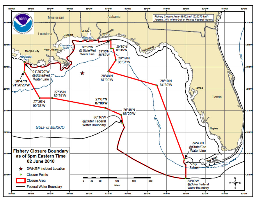 Fishery Closure area is almost over the Florida Keys. This area represents "the area the oil is projected to cover two days out." Not much commentary about this in the media yet. I wonder how accurate this is? HOW MUCH or how little does it take for NOAA to close an area to fishing anyway? NOAA animation of plume. Arrival at the Dry Tortugas forecast by June 4, 2010. "NOAA has extended the northern and southern boundaries of the closed fishing area in the Gulf of Mexico to capture portions of the slick moving into waters off eastern Alabama and the western tip of the Florida panhandle, as well as some large patches of sheen moving onto the west Florida shelf and southward to Cuban waters. This federal closure does not apply to any state waters. Closing fishing in these areas is a precautionary measure to ensure that seafood from the Gulf will remain safe for consumers." Deepwater Horizon Oil Spill: Federal Fishery Closure Frequently Asked Questions June 2010 Why is NOAA Fisheries Service prohibiting fishing in certain areas? NOAA Fisheries Service prohibited fishing in the area as a precautionary measure to ensure public safety and assure consumer confidence in Gulf of Mexico seafood. The goal of the closure is to encompass the area the spill has actually covered (based on a combination of satellite and overflight data) as well as the area the oil is projected to cover two days out. NOAA Fisheries Service strongly advises fishermen not to fish in areas where oil or oil sheens (very thin layers of floating oil) are present, even if those areas are not currently closed to fishing. A process to expedite modifications to the fishing closed area in the Gulf of Mexico has been established. Boundaries of the fishing closed area can be modified daily, based on dynamic oil spill conditions. The current Roff's chart of oil spill distribution:  http://www.roffs.com/deepwaterhorizon.html ... Barbie posted an interesting discussion of the physical and biological interaction of the spill in Gulf waters from RSMAS. It is well worth reading, could provide some insight on things to come. http://www.rsmas.miami.edu/oil-spill...rspective.html .
__________________
FKA, Inc. transcribed by: Rick Iossi Last edited by ricki; 06-03-2010 at 05:05 AM.
|
|
#7
06-03-2010, 05:04 AM
|
||||
|
||||
|
Spill Meeting on Monday at the IGFA in Dania, FL to discuss impacts on Diving, fishing, tourism, marine properties on the SE Coast. Listed as for captains, crew, property owners, hotel and restaurant owners. Two marine scientists, various captains will be presenting. Oh, there is an attorney sponsor who will be presenting as well likely discussing law suit opportunities. This was on a link that Barbie put up.
 CLICK FOR FULL SIZED IMAGE ... "Oil sheen closes in on Tortugas Fishing is banned in parts of the Florida Keys National Marine Sanctuary west of the Dry Tortugas, where an oil sheen was 100 miles away and closing in on the area, federal officials declared Wednesday. Nearly 38 percent of the Gulf of Mexico, or 88,502 square miles, is now closed to fishing because of the Deepwater Horizon oil spill, said Roy Crabtree, the National Marine Fisheries Service's southeast regional director. The National Oceanic and Atmospheric Administration (NOAA) expanded its fishing ban in federal waters effective at 6 p.m. after projecting the sheen would be within 50 or 60 miles of the Tortugas by Friday, Crabtree said. A spawning area for grouper and snapper that includes the Tortugas Ecological Reserve South and Riley's Hump is now in the closed area, according to a satellite overlay of the closure coordinates. While fishing already was banned in the reserve because it is an environmentally protected area, Florida Keys-based commercial and recreational fishermen often fish just outside the reserve. The closure comes at the height of the dolphin fishing season and as mutton snapper are congregating on the reef to spawn. "This is a very grave situation," said Florida Keys Commercial Fishermen's Association Executive Director Bill Kelly. Crabtree called for more sampling of water, fish and shellfish to see if they are being contaminated by oil, he said. "We need first-hand knowledge of what's going on," Crabtree said. A Mote Marine Laboratory underwater drone has not uncovered any traces of oil in the Tortugas, spokeswoman Nadine Slimak said Wednesday. The drone, called Waldo, was brought back to Mote and substituted with a new one this week after it had problems navigating the currents. Florida Gov. Charlie Crist requested the U.S. Department of Commerce declare a federal fishery disaster for Florida on Wednesday, as an oil sheen and tar balls were within 10 miles of Pensacola beaches. Crist cited the impact on the state's fishing industry in his letter to Commerce Secretary Gary Locke." More at: http://keysnews.com/node/23778
__________________
FKA, Inc. transcribed by: Rick Iossi
|
|
#8
06-04-2010, 03:53 PM
|
||||
|
||||
|
Some tar balls arrive at Pensacola in Panhandle of Florida. Just heard on NBC that the oil sheen is about nine miles offshore currently.
"Cap collects some Gulf oil; crude washes into Fla. By MELISSA NELSON and JAY REEVES (AP) – 35 minutes ago PENSACOLA BEACH, Fla. — Waves of gooey tar balls crashed into the white sands of the Florida Panhandle on Friday as BP engineers adjusted a sophisticated cap over the Gulf oil gusher, trying to collect the crude now fouling four states. Even though the inverted funnel-like device was set over the leak late Thursday, crude continued to spew into the sea in the nation's worst oil spill. Engineers hoped to close several open vents on the cap throughout the day in the latest attempt to contain the oil. As they worked on the system underwater, the effect of the BP spill was widely seen. Swimmers at Pensacola Beach rushed out of the water after wading into the mess while children played with it on the shore and others inspected the clumps with fascination, some taking pictures. Brown pelicans coated in chocolate syrup-like oil flailed and struggled in the surf on a Louisiana island, where the beached was stained in hues of rust and crimson, much like the color of drying blood. "In Revelations, it says the water will turn to blood. That's what it looks like out here — like the Gulf is bleeding," said P.J. Hahn, director of coastal zone management for Plaquemines Parish as he kneeled down to take a picture of an oil-coated feather. "This is going to choke the life out of everything.""  http://www.sun-sentinel.com ... Jeff Masters speculates on where to from here with regard to the spill: "Onshore winds out of the south, southwest, or west are expected to blow over the northern Gulf of Mexico over through Tuesday, resulting in a continued threat of landfalling oil to Alabama, Mississippi, and the Florida Panhandle, according to the latest trajectory forecasts from NOAA and the State of Louisiana. The latest ocean current forecasts from the NOAA HYCOM model show that these winds will generate a 0.5 mph current flowing from west to east along the Florida Panhandle coast Sunday through Tuesday. If this current develops as predicted, it will be capable of bringing light amounts of oil as far east as Panama City, Florida, by Wednesday. Long range surface wind forecasts from the GFS model for the period 8 - 14 days from now predict a return to a southeasterly wind regime, which would bring the oil back over Louisiana by mid-June. If you spot oil, send in your report to http://www.gulfcoastspill.com/, whose mission is to help the Gulf Coast recovery by creating a daily record of the oil spill. Long range oil spill outlook The National Center for Atmospheric Research (NCAR) issued a press release yesterday showing 4-month model runs (Figure 1) of where the Deepwater Horizon oil spill might go. The model runs show that given typical ocean currents in the Gulf of Mexico, we can expect the oil to eventually affect most of the Florida Panhandle, Keys, and Florida East Coast, as well as coastal areas of South Carolina and North Carolina. Very little oil makes it to the West Florida "Forbidden Zone", where offshore-moving surface currents dominate. The oil may eventually affect three foreign countries: Mexico along the northern tip of the Yucatan Peninsula, Cuba near Havana, and the Bahamas in the Bimini Islands and along the western side of Grand Bahama Island. Once oil does get into the Loop Current, it will probably reach the coasts of France, Spain, and Portugal in about a year. The oil will be too dilute by then to be noticeable, though." Continued at: http://www.wunderground.com/blog/JeffMasters/show.html ... It has to go somewhere, here is what one model shows. This mistake could go a very long way impacting a tremendous area. "Ocean currents likely to carry oil along Atlantic coast June 03, 2010 BOULDER—A detailed computer modeling study released today indicates that oil from the massive spill in the Gulf of Mexico might soon extend along thousands of miles of the Atlantic coast and open ocean as early as this summer. The modeling results are captured in a series of dramatic animations produced by the National Center for Atmospheric Research (NCAR) and collaborators. "Oil has been pouring into the Gulf of Mexico since April 20 from a blown-out undersea well, the result of an explosion and fire on an oil rig. The spill is located in a relatively stagnant area of the Gulf, and the oil so far has remained relatively confined near the Louisiana and Alabama coastlines, although there have been reports of small amounts in the Loop Current. The model simulations show that a liquid released in the surface ocean at the spill site is likely to slowly spread as it is mixed by the ocean currents until it is entrained in the Loop Current. At that point, speeds pick up to about 40 miles per day, and when the liquid enters the Atlantic’s Gulf Stream it can travel at speeds up to about 100 miles per day, or 3,000 miles per month."" Continued at: http://www2.ucar.edu/news/ocean-curr...atlantic-coast .
__________________
FKA, Inc. transcribed by: Rick Iossi Last edited by ricki; 06-04-2010 at 05:41 PM.
|
|
#9
07-08-2010, 05:50 AM
|
||||
|
||||
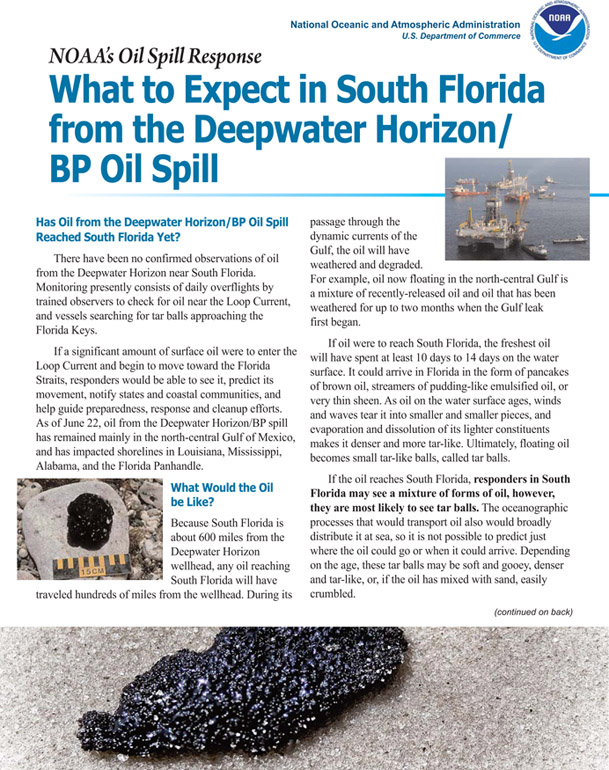 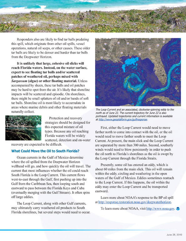 You can download the original pdf files at: http://response.restoration.noaa.gov...uthflorida.pdf and regarding reefs: What Happens When Oil Collides with Coral? As Researchers Struggle to Bring Dying Reefs Back to Life, They Worry about Threat of Approaching Oil By Kelly Cobiella June 15, 2010  Click image for CBS video (CBS) Marine scientist Meaghan Johnson is fighting a battle few ever see - she's slowly bringing Florida's coral reefs back to life, reports CBS News correspondent Kelly Cobiella. Thirty feet below the surface Johnson showed Cobiella row after row of coral alive and growing after decades of being battered by disease and warmer water. All of it was planted here by scientists and each fragment started out as only a couple of inches tall. It all started in Ken Niedemeyer's backyard in the Florida Keys. His daughter needed a 4-H project so they decided to try growing coral. "Good thing I never read about it because everyone said it couldn’t be done," Neidermeyer said. Their technique worked. They took it to researchers and nine years later it has blossomed to this - the largest man-made nursery project with 5,000 coral colonies growing underwater from Fort Lauderdale to the Virgin Islands. Scientist clip and plant new coral just like pruning a tree, and anchor it with underwater glue. When the coral is big enough, it's moved to a reef to replace dead or dying coral. "It's just amazing what happens," Neidermeyer said. "A lot more habitat for fish, for juvenile fish, for large fish, for invertebrates." But they're now facing a new threat - BP oil. Every day, Johnson anxiously checks the forecast for the Gulf "loop current," the system that seasonally carries water, and anything in the water, eastward through the Florida Keys. "It's definitely devastating to watch what's happening in the gulf and know that it could come here," Johnson said. "I think we are all worried about what's going to happen in this project." There's little they can do to protect the nurseries. If the oil is weathered and weakened enough, Johnson thinks the young coral just might pull through. "Those are our little babies, you know," Johnson said. "We put those guys out there. And it's nice to come back in a month or two and see them actually growing. And feel like, 'Wow, I did that. You know, I'm helping. I'm doing something good.'" With oil coming a little closer every day, she's hopeful at least some of that "good" will survive. " http://www.cbsnews.com/stories/2010/...n6585811.shtml More about the Florida Reef Resilience Program at: http://frrp.org/ and warmer waters at: http://www.npr.org/templates/story/s...oryId=14212267
__________________
FKA, Inc. transcribed by: Rick Iossi
|
|
|
|


 Hybrid Mode
