"Scientist: Oil may be entering Gulf Loop current, could reach Palm Beach County
Oil may be on its way.
New satellite images show oil starting to enter the Gulf Loop current, which would pull it through the Florida Keys, into the Gulf Stream and up to Palm Beach County, according to a scientist tracking the oil spewing into the gulf.
The new images, taken Saturday by NASA's Jet Propulsion Laboratory, "clearly [show] that the oil is being pulled into the Loop current," according to a release from Mitch Roffer, an oceanographer who runs Roffer's Ocean Fishing Forecasting Service and has been providing daily updates on the spill's movement.
"We still don't know how long it's going to take to get around to the Keys and then the east coast of Florida - it just remains to be seen," Roffer said Saturday.
That process, which is difficult to predict, would take at least a week, and possibly several, scientists say."
Continued:
http://www.sun-sentinel.com/news/pal...,7727606.story
"ROFFS™ OCEANOGRAPHIC ANALYSIS FOR THE DEEPWATER HORIZON OIL SPILL AREA
UPDATED SATURDAY 15 MAY 2010 (16:00 HRS)
See enclosed PDF analysis as the graphic is enclosed. Higher resolution graphics are
available. We received some dramatic and clear synthetic aperture radar (SAR) imagery from the NASA Jet Propulsion Laboratory (thank you Ben Holt) that clearly shows that the oil is being pulled into the Loop Current. The first two images are from today and the third and fourth one is from May 12, 2010. I have annotated the imagery so you can see the oil. On the image from May 12, one can also see the tendrils of oil that have moved west and southwest. These images confirm again our water mass– sequential image analysis technique that we have been using. See the analyses from earlier this week on other evidence of this. Obviously the oil has moved further into the Loop Current system
than we had seen the last few days using infrared, ocean color and RGB satellite data.
The question now is how fast and how much of this oil will be entrained into the Loop Current.The other critical questions are what is below the slick and what is in the water masses we have been tracking since the original spill? What will we do to stop the impacts of this oil and the other oil moving along the northern Gulf of Mexico."
Continued at:
http://www.roffs.com/DeepwaterHorizo...il15May10b.pdf
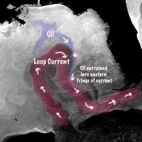
JPL Imagery via Roffs. Labeling and highlighted areas have been added to aid clarity.
You can see static and animated JPL sat. imagery of the Gulf, oil plume and Loop Current at ROFFS website where the plume appears to merge with the Loop Current at:
http://www.roffs.com/deepwaterhorizon.html
The animated imagery shows what appears to be the entrainment of the oil plume more clearly than the image above.

More Roffs imagery from earlier in the month.
From:
http://www.marlinmag.com/news/news/r...000082714.html
Information was not provided regarding quantities and nature of the floating component of the spill that may be transported into the Straits of Florida. What near term impacts that may be experienced in these areas, if any, particularly closer to shore will be controlled in part by these factors and local weather/current conditions. Roffs previously monitored transport of oil spills created by Hurricane Katrina via the Loop Current into the Straits.
.